Where is Cyprus?
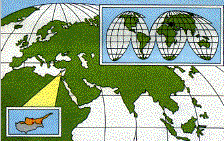 Cyprus is the most easterly
of the Mediterranean islands and the third largest in the area after Sicily
and Sardinia
in the Mediterranean.
Cyprus is the most easterly
of the Mediterranean islands and the third largest in the area after Sicily
and Sardinia
in the Mediterranean.
At the nearest coastal points
it is 40 miles from Turkey, 60 miles from Syria,
and 250 miles from Egypt.
North Cyprus is some 100
miles long, 40 miles across at its widest point and has a total area of
1357 square miles, comprising nearly 36% of the island of Cyprus.
Boundaries in Cyprus
 An in depth pictorial guide
to land
boundaries in Cyprus
An in depth pictorial guide
to land
boundaries in Cyprus
Geography of the island
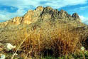 The
geography of North Cyprus is characterized by a unique blend of
mountains, plains, and beaches. The Kyrenia (Beşparmak
/ Five Finger) mountain range, with its
magnificent jagged limestone peaks, the highest of which is Mount İçova at 3,357 ft. runs along most of
the northern coastline from a startling backdrop.
The
geography of North Cyprus is characterized by a unique blend of
mountains, plains, and beaches. The Kyrenia (Beşparmak
/ Five Finger) mountain range, with its
magnificent jagged limestone peaks, the highest of which is Mount İçova at 3,357 ft. runs along most of
the northern coastline from a startling backdrop.
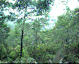 To the east
of the island the mountain range loses height as it extends along the
narrow peninsula known as Karpas,
or more affectionately, `The Panhandle'.
To the east
of the island the mountain range loses height as it extends along the
narrow peninsula known as Karpas,
or more affectionately, `The Panhandle'.
It is here that the best beaches of Cyprus can be found, long wide
empty bays of the purest sand that stretch for miles.
Cities and the towns
To the south of the Kyrenia range lies Nicosia (Lefkoşa)
(population 39,000), the capital of North Cyprus, through which runs
the boundary, or as it is called `The Green Line' separating the North
from South Cyprus.
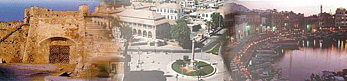
The other major centers are the tourist resorts of Famagusta
(Mağusa) (population 30,000), Kyrenia (Girne)
(population 22,000), and the citrus center of Güzelyurt
(Morphou) (population 15,000).
Local Time
Click
to see the current local time in North Cyprus.